CLIMATE OF SAN FRANCISCO |
 |
CLIMATE OF SAN FRANCISCO |
|
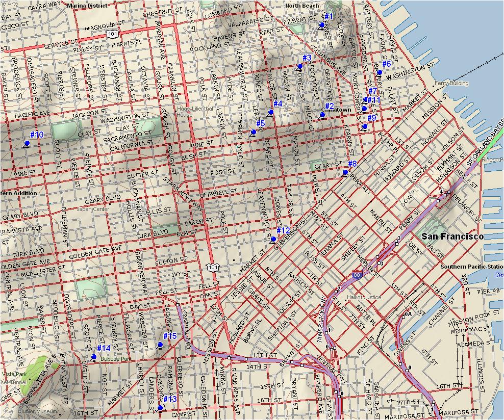
SAN FRANCISCO STATION HISTORY (Map)
Weather conditions have been observed in San Francisco since 1847 when the first observations were made at the Presidio of San Francisco. However, the Presidio records were taken only intermittently. It was not until the summer of 1849, when the population of San Francisco increased significantly because of the Gold Rush, that the continuous rainfall record began. Official continous temperature records have been kept from 1871 until present. Measurements of wind, pressure, humidity and sunshine were taken for approximately 102 years, also beginning in 1871, but were discontinued in 1973 when the Weather Bureau Office moved to San Francisco Airport.
The continuous San Francisco rainfall record extends back to August 14, 1849 when Thomas Tennent, a maker of nautical and mathematical instruments, began taking daily measurements shortly after his arrival in San Francisco. Tennent was born a Quaker in Philadelphia in 1822, and apprenticed as an instrument maker. Early in 1849 he made the 95 day journey to California from the east coast via the Panama Canal, walking the final 110 miles from Monterey. While waiting for his instruments to arrive from the East, Thomas Tennent served as a surveyor and also as a miner (Bay of San Francisco: A History, 1892).
When he finally set up his shop, making nautical instruments for the many ships stopping at San Francisco during the Gold Rush, he installed a rain gauge on the roof. This location was on the northeast corner of Union and Dupont (now Grant), and was the first of six locations at which Thomas Tennent would take observations between August 14, 1849 and February 1, 1871. These sites were all confined to a relatively small area in the northeastern quadrant of San Francisco (see Table 1 and Figure 1). He supplied his meteorological data, along with sunrise, sunset, moon and tide tables, to the local newspapers. His meteorological data were eventually published in Tennent's Nautical Almanac beginning in 1868 and continuing until 1890.
Tennent became a prominent San Franciscan and served three terms as a member of the Board of Supervisors. During his tenure as a surveyor he designed the street layout for all of San Francisco west of Larkin Street, and the house numbering system which is still in use (Bay of San Francisco: A History, 1892).
Several other individuals also took weather observations during the Gold Rush. Dr. William O. Ayres took complete weather observations from 1856 until 1868; however, nearly thirty months of data during that period are either missing or were never taken (Loffman, 1975).
Another prominent early San Franciscan, Dr. Henry Gibbons took observations of rainfall and temperatures from 1850 until at least 1880. Like Tennent he sold his data to the newspapers as a Meteorological Table. Gibbons was one of the founders of California Academy of Sciences, a President of the California State Medical Society and a professor at the Medical College of the Pacific (Bay of San Francisco: A History, 1892).
McAdie (1913) also notes that records of rainfall and temperature were taken by Dr. T. M. Logan and Mr. John Pettee. This is the only reference in the literature to these individuals.
On March 1, 1871 the U.S. government took over as the official weather observer for San Francisco when the Army Signal Service began to take the observations. The Signal Service accepted the rainfall data from Thomas Tennent as the "official" early record. This was because of Tennent's expertise as an instrument maker and the fact that he recorded rainfall to the nearest one-hundredth of an inch, while Gibbons measured only to the nearest one-tenth inch (Loffman, 1975). Because of the extreme variability of temperatures, the early temperature records of Tennent, Ayres and Gibbons were not incorporated into the official record (Loffman, 1975). Consequently, the official San Francisco temperature records do not begin until 1871.
From that time to present, the U. S. government has taken weather observations in San Francisco, first as the Signal Service, and then the United States Weather Bureau (later renamed the National Weather Service). Since 1871, the observation site was moved another six times, but has remained in the northeastern quadrant of the city.
The ninth observation site, at the Mills Building, was destroyed by the earthquake and fire on April 18, 1906, and observations were taken at a private residence about 2 miles to the west until October 1, 1906. There is a discrepancy in the records (Null, 1978; Pericht 1988) as to whether observations were taken between April 18 and May 1, 1906. However, records complied by McAdie (1906) indicate rainfall for San Francisco on several dates during that period. This corresponds to data available at several other nearby sites during the same period, and has been incorporated into this research.
In 1936, the observation site was moved to the roof of the Federal Office Building (FOB) on Fulton Street, where it remained until 1983. The forty-seven years at this locale was the longest at any site. In April 1973, the Climatology Office in the Federal Building was closed. Readings from that site, and subsequently Mission Dolores, were transmitted by telephone line to the National Weather Service Office at San Francisco International Airport. Observers discovered that there was a "minor malfunction" in the rain gauge at the FOB from January 1973 to April 1982 (Pericht, 1988). The FOB readings were found to be only about 70% of actual amounts (by comparison to data from surrounding sites). The record was corrected by substituting data from KGO Television, which was only 2 blocks away, and has been accepted by the National Climatic Data Center (NCDC).
The most recent San Francisco sites are at Mission Dolores, Duboce Park and the United State Mint, 1.3 miles south of the FOB then 0.5 miles northwest and now 1.0 miles southwest, where it was moved on April 18, 1983, June 11, 1997 and January 2007 respectively. These sites are the southernmost of the 15 locations, yet remain within a 1.5 mile radius circle that encompasses all of the aforementioned sites. [It should be noted that the US Mint site is the first to be at ground level and not on a rooftop.]
The rain gauge that Thomas Tennent used was a six inch square container which funneled into a two inch square receiver, and was capable of holding 4 inches of precipitation (Melnick, 1978). With the establishment of the Signal Service observations in 1871, all observations have been made using a "standard" eight inch circular gauge. Readings from the site were telemetered to the NWS office at San Francisco Airport beginning in 1973 and then to the NWS office in Monterey in 1994..
Acknowledgements: Special thanks to the dedicated people who have faithfully taken and kept the San Francisco weather data for a century and a half.
Map of San Francisco Weather Station Locations
(click to enlarge)
# Location Dist. from Prev. Began Ended Elev. ASL 1 NE Corner Union & Dupont (Grant) 8/14/1849 7/1/1851 125' 2 Stockton & California 0.6 mi SSW 7/2/1851 7/1862 175' 3 Powell between Pacific & Broadway 0.3 mi NNW 7/1862 Summer 1863 120' 4 Sacramento between Taylor & Jones 0.4 mi SW Summer '63 7/1864 330' 5 Leavenworth between Pine & California 0.2 mi SW 7/1874 7/1866 260' 6 Battery St. between Washington & Jackson 0.9 mi ENE 7/1866 2/1/1871 14' 7 Merchants Exch. Bldg (Sacramento & Leidesdorff) 0.2 mi SW 2/2/1871 9/3/1890 15' 8 Phelan Bldg. (Market & O'Farrell) 0.5 mi SW 9/4/1890 10/31/92 41' 9 Mills Bldg. (220 Montgomery St) 0.3 mi 11/1/1892 4/18/1906 25' 10 Residence (3018 Clay St) 3.1 mi W 5/1/1906 10/1/1906 257' 11 Merchants Exch. Bldg (465 California St) 3.0 mi E 10/1/1906 5/12/1936 17' 12 Federal Office Bldg* (50 Fulton St) 1.0 mi SW 5/13/1936 4/18/1983 102' 13 Mission Dolores (16th & Dolores St) 1.3 mi SW 4/18/1983 6/10/1997 75' 14 Duboce Park (Duboce & Scott) 0.5 mi NW 6/11/1997 1/25/2007 175' 15 US Mint (Hermann & Buchanan) 0.4 mi E 1/26/2007 present 155' * Note: Due to a malfunctioning raingauge, data for the period of October 1, 1973 through March 10, 1982 has been corrected using rainfall data from the nearby KGO-TV gauge. This site is located at 277 Golden Gate Ave., approxmately 500 feet north of the Federal Office Building. It had a rooftop exposure with a ten inch tipping bucket gauge located at 125 feet MSL.
Copyright © 2009, Golden Gate Weather Services.
Reproduction in full or part is prohibited without permission.